Tuesday, April 30, 2013

Eastern Shore Trip, Part 1: The Norfolk Horror Show

After several stressful months, I finally got a week off from work. I did lots of driving during the week, but mostly on roads I've traveled before or at night, so very few pictures are available from that. At the end of the week, I made my return to Hampton Roads, for the purpose of visiting the Eastern Shore for the first time. I'd been on the Chesapeake Bay Bridge-Tunnel before, but it was on a fishing trip on the island just before the first tunnel. In addition to visiting the Eastern Shore, I wanted to hang out with this guy and test drive a car or two.

First, however, I had to survive the increasingly boring segment of US 460 between Petersburg and Suffolk. This is in Windsor.


Well into Suffolk now, getting near Chesapeake. My windshield was dirty from an earlier trip; glass cleaner didn't help much.


To get to Elric's place, taking I-64 all the way to exit 272 or 273 would be faster, but I wanted to clinch VA 168 first.


Onto VA 168 northbound.


The banner-below-the-shield error is pretty rare in Virginia. This was also present in 2008.


Meeting VA 407.


VA 407 actually does not continue west here. In 2008 these were normal-looking shields.


VA 166 and US 460 prepare to join VA 168 across the Campostella Bridge.


Upon reaching downtown Norfolk, US 460, VA 166, and VA 168 all go their separate ways.


VA 168 becomes Tidewater Drive. It meets US 58 at an odd intersection of which this assembly is actually in the middle.


Tidewater Drive has a few of these underpasses.


VA 168 meets VA 247.


Normal-looking signage in Norfolk?


...yeah, that's more like them.


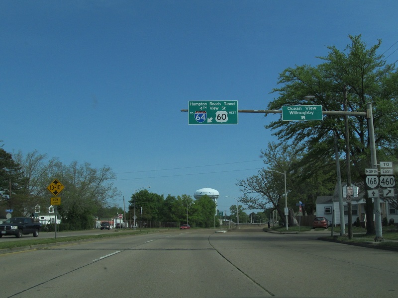
VA 168 prepares to end at US 60 in a bizarre configuration. Coming from VA 168, you can't continue west on Ocean View Avenue, but have to turn onto 4th View Street. Coming from Ocean View, you can't turn onto 4th View.


Going the other way now, on our way to a car dealership.


This is leftover from before the Ocean View/4th View intersection was reconfigured.


Going into Virginia Beach now, we see this terrible set of overheads on the border.


Virginia Beach isn't good at signage either.


After I test drove this 2010 Honda Civic Si and got lunch, we headed for the Chesapeake Bay Bridge-Tunnel. On the way we saw this good-looking VA 403 shield which, sadly, is not on VA 403.


In part 2, we'll get to the CBBT.

Tuesday, April 9, 2013

A Different Mecklenburg Saga, Part V: Salisbury Back To Virginia

Excuse the delay, I've been very busy lately.


US 52 joins/leaves I-85 here.


Spencer and East Spencer don't show up together here, so no confusing "Spencer E Spencer" sign.


More construction.


Belmont Road, another name of a road that also exists in the Richmond area.


Exit 87 is where US 29, 70, & 52 leave I-85, while I-85 Business, and in the future I-285, begin.


North of I-85 Business, I-85 is the Richard Childress Freeway. Childress is a NASCAR owner who is from the area.


Here's an interesting setup. The North Carolina Vietnam War Veterans Memorial is on I-85 here, and to provide easier access (and save money, I assume), I-85 was built to have all right-side exits to it, so it crosses under itself. The northbound lanes are west of the southbound lanes here.


Back in the Triad area again.


Needs more greenout.


Shields in the lanes. There were nine of these, three for each lane that stays I-85. This was the last of all of them.


Re-entering the Greensboro Urban Loop.


Departing the Urban Loop back to I-85/40.


Now at the other end of the I-85/40 concurrency. I-85 and NC 86 Truck form a wrong-way concurrency here that continues on 85 solo.


Crossing over water.


Back to the Old Dominion.


The most interesting thing I noticed about NC signage? No Clearview. That alone makes me think more highly of it than Virginia's. I'd like to go out of state again soon, but we'll see...